


ROCHE DES BRUYÈRES

surceneux
User
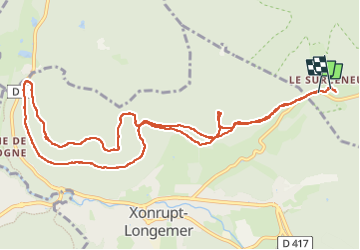

Length
12 km

Max alt
971 m

Uphill gradient
345 m
Km-Effort
16.6 km

Min alt
812 m

Downhill gradient
354 m
Boucle
Yes
Creation date :
2025-03-06 13:12:24.103
Updated on :
2025-03-06 17:05:32.509
3h00
Difficulty : Easy

FREE GPS app for hiking
 SityTrail
IGN / Geographical institutes
SityTrail Plus
The world is yours!
About
Trail Walking of 12 km to be discovered at Grand Est, Vosges, Ban-sur-Meurthe-Clefcy. This trail is proposed by surceneux.
Description
SURCENEUX ROCHE DES BRUYÈRES AR
Positioning
Country:
France
Region :
Grand Est
Department/Province :
Vosges
Municipality :
Ban-sur-Meurthe-Clefcy
Location:
Unknown
Start:(Dec)
Start:(UTM)
347684 ; 5328994 (32U) N.
Comments