


départ nans sous saint anne

gerardmicheline
User
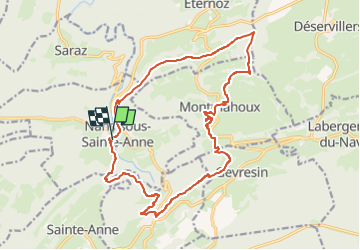

Length
19 km

Max alt
820 m

Uphill gradient
717 m
Km-Effort
29 km

Min alt
361 m

Downhill gradient
722 m
Boucle
Yes
Creation date :
2025-03-07 09:31:16.416
Updated on :
2025-03-07 09:33:24.818
6h29
Difficulty : Very difficult

FREE GPS app for hiking
 SityTrail
IGN / Geographical institutes
SityTrail Plus
The world is yours!
About
Trail Walking of 19 km to be discovered at Bourgogne-Franche-Comté, Doubs, Nans-sous-Sainte-Anne. This trail is proposed by gerardmicheline.
Positioning
Country:
France
Region :
Bourgogne-Franche-Comté
Department/Province :
Doubs
Municipality :
Nans-sous-Sainte-Anne
Location:
Unknown
Start:(Dec)
Start:(UTM)
727937 ; 5206845 (31T) N.
Comments