


départ nans sous sainte anne

gerardmicheline
User
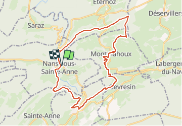

Length
18.8 km

Max alt
820 m

Uphill gradient
710 m
Km-Effort
28 km

Min alt
361 m

Downhill gradient
709 m
Boucle
Yes
Creation date :
2025-03-07 09:48:26.61
Updated on :
2025-03-07 09:49:41.734
6h25
Difficulty : Very difficult

FREE GPS app for hiking
 SityTrail
IGN / Geographical institutes
SityTrail Plus
The world is yours!
About
Trail Walking of 18.8 km to be discovered at Bourgogne-Franche-Comté, Doubs, Nans-sous-Sainte-Anne. This trail is proposed by gerardmicheline.
Positioning
Country:
France
Region :
Bourgogne-Franche-Comté
Department/Province :
Doubs
Municipality :
Nans-sous-Sainte-Anne
Location:
Unknown
Start:(Dec)
Start:(UTM)
271880 ; 5207036 (32T) N.
Comments