


Entre champs et vignes

Mascart
User

Length
9.4 km

Max alt
286 m

Uphill gradient
273 m
Km-Effort
12.9 km

Min alt
122 m

Downhill gradient
221 m
Boucle
No
Creation date :
2025-03-07 07:54:17.573
Updated on :
2025-03-07 11:13:58.854
2h18
Difficulty : Medium

FREE GPS app for hiking
 SityTrail
IGN / Geographical institutes
SityTrail Plus
The world is yours!
About
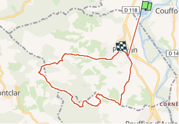
Trail Walking of 9.4 km to be discovered at Occitania, Aude, Couffoulens. This trail is proposed by Mascart.
Description
boucle à partir de Preixan (11)
Positioning
Country:
France
Region :
Occitania
Department/Province :
Aude
Municipality :
Couffoulens
Location:
Unknown
Start:(Dec)
Start:(UTM)
442622 ; 4778198 (31T) N.
Comments