


Vernegues

mhetpierre
User
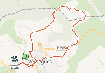

Length
6.2 km

Max alt
326 m

Uphill gradient
133 m
Km-Effort
8 km

Min alt
217 m

Downhill gradient
137 m
Boucle
Yes
Creation date :
2025-03-07 10:10:14.0
Updated on :
2025-03-07 13:00:41.818
2h49
Difficulty : Medium

FREE GPS app for hiking
 SityTrail
IGN / Geographical institutes
SityTrail Plus
The world is yours!
About
Trail Walking of 6.2 km to be discovered at Provence-Alpes-Côte d'Azur, Bouches-du-Rhône, Vernègues. This trail is proposed by mhetpierre.
Positioning
Country:
France
Region :
Provence-Alpes-Côte d'Azur
Department/Province :
Bouches-du-Rhône
Municipality :
Vernègues
Location:
Unknown
Start:(Dec)
Start:(UTM)
674652 ; 4839224 (31T) N.
Comments