


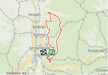
Boucle autour de Mont (au dessus de Loudenvielle 65).

yvesdelafforest
User

Length
13.9 km

Max alt
1725 m

Uphill gradient
642 m
Km-Effort
22 km

Min alt
1235 m

Downhill gradient
643 m
Boucle
Yes
Creation date :
2025-03-07 09:18:55.974
Updated on :
2025-03-07 15:22:07.112
5h57
Difficulty : Very difficult

FREE GPS app for hiking
 SityTrail
IGN / Geographical institutes
SityTrail Plus
The world is yours!
About
Trail Walking of 13.9 km to be discovered at Occitania, Hautespyrenees, Loudervielle. This trail is proposed by yvesdelafforest.
Positioning
Country:
France
Region :
Occitania
Department/Province :
Hautespyrenees
Municipality :
Loudervielle
Location:
Unknown
Start:(Dec)
Start:(UTM)
289331 ; 4742522 (31T) N.
Comments