


Norroy Canrobert BS

bstebe
User
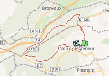

Length
8.2 km

Max alt
371 m

Uphill gradient
212 m
Km-Effort
11.1 km

Min alt
223 m

Downhill gradient
211 m
Boucle
Yes
Creation date :
2025-03-07 18:38:44.879
Updated on :
2025-03-07 18:56:48.361
2h30
Difficulty : Medium

FREE GPS app for hiking
 SityTrail
IGN / Geographical institutes
SityTrail Plus
The world is yours!
About
Trail Walking of 8.2 km to be discovered at Grand Est, Moselle, Norroy-le-Veneur. This trail is proposed by bstebe.
Positioning
Country:
France
Region :
Grand Est
Department/Province :
Moselle
Municipality :
Norroy-le-Veneur
Location:
Unknown
Start:(Dec)
Start:(UTM)
289024 ; 5451644 (32U) N.
Comments