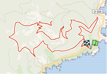
Trail Walking Saint-Raphaël - Pic du cap roux - Photo
© OpenStreetMap contributors
Length
Length
10.6 km
Max alt
Max alt
440 m
Uphill gradient
Uphill gradient
503 m
Km-Effort
Km-Effort  
17.3 km
Min alt
Min alt
28 m
Downhill gradient
Downhill gradient
504 m
Boucle
Boucle
Yes
Creation date :
2025-03-08 08:28:54.942
Updated on :
2025-03-09 16:28:41.782

(0 Reviews)

Walking
Walking
3h55
Difficulty : Difficult

Scan this QR Code to open this trail in the SityTrail application

FREE GPS app for hiking

Logo SityTrail SityTrail

IGN / Geographical institutes

Download SityTrail from the App Store Download SityTrail from Google Play

Logo SityTrail SityTrail Plus

The world is yours!

Download SityTrail from the App Store Download SityTrail from Google Play Download SityTrail on Huawei AppGallery

About

Trail Walking of 10.6 km to be discovered at Provence-Alpes-Côte d'Azur, Var, Saint-Raphaël. This trail is proposed by Daniel.BRUN-PICARD.

Description

Randonnée d'une beauté exceptionnelle avec de superbes points de vue et des couleurs plein les yeux. Un grand merci à nos animateurs du Touring Club du Var qui nous ont fait découvrir  ces paysages.

Elevation profile

Photos

Positioning

Country:
France
Region :
Provence-Alpes-Côte d'Azur
Department/Province :
Var
Municipality :
Saint-Raphaël
Location:
Unknown
Start:(UTM)
331514 ; 4812811 (32T) N.


Close
My subscriptions