


Lucheux

jpblimond
User
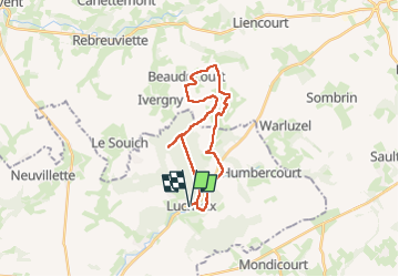

Length
21 km

Max alt
171 m

Uphill gradient
232 m
Km-Effort
25 km

Min alt
84 m

Downhill gradient
232 m
Boucle
Yes
Creation date :
2025-03-08 12:05:31.0
Updated on :
2025-03-08 16:56:30.286
4h49
Difficulty : Medium

FREE GPS app for hiking
 SityTrail
IGN / Geographical institutes
SityTrail Plus
The world is yours!
About
Trail Walking of 21 km to be discovered at Hauts-de-France, Somme, Lucheux. This trail is proposed by jpblimond.
Positioning
Country:
France
Region :
Hauts-de-France
Department/Province :
Somme
Municipality :
Lucheux
Location:
Unknown
Start:(Dec)
Start:(UTM)
457930 ; 5560687 (31U) N.
Comments