


Château-Thierry du 09/03/2025

VANDERPUTTENMi
User GUIDE

Length
8.4 km

Max alt
182 m

Uphill gradient
170 m
Km-Effort
10.7 km

Min alt
55 m

Downhill gradient
170 m
Boucle
Yes
Creation date :
2025-03-09 08:29:31.399
Updated on :
2025-03-10 12:23:54.701
2h25
Difficulty : Medium

FREE GPS app for hiking
 SityTrail
IGN / Geographical institutes
SityTrail Plus
The world is yours!
About
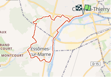
Trail Walking of 8.4 km to be discovered at Hauts-de-France, Aisne, Château-Thierry. This trail is proposed by VANDERPUTTENMi.
Photos

Positioning
Country:
France
Region :
Hauts-de-France
Department/Province :
Aisne
Municipality :
Château-Thierry
Location:
Unknown
Start:(Dec)
Start:(UTM)
529116 ; 5432370 (31U) N.
Comments