


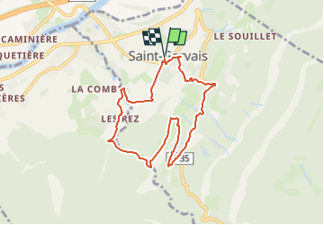
Gorges de la Drevenne-14/03/2025-1/2J-G3

lmc
User

Length
7.8 km

Max alt
509 m

Uphill gradient
349 m
Km-Effort
12.4 km

Min alt
198 m

Downhill gradient
349 m
Boucle
Yes
Creation date :
2025-03-10 09:21:39.555
Updated on :
2025-03-10 09:22:47.543
2h49
Difficulty : Easy

FREE GPS app for hiking
 SityTrail
IGN / Geographical institutes
SityTrail Plus
The world is yours!
About
Trail Walking of 7.8 km to be discovered at Auvergne-Rhône-Alpes, Isère, Saint-Gervais. This trail is proposed by lmc.
Positioning
Country:
France
Region :
Auvergne-Rhône-Alpes
Department/Province :
Isère
Municipality :
Saint-Gervais
Location:
Unknown
Start:(Dec)
Start:(UTM)
694886 ; 5008384 (31T) N.
Comments