


Rando pédestre Cauterets

topolino
User
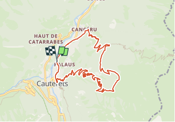

Length
11.5 km

Max alt
1646 m

Uphill gradient
793 m
Km-Effort
22 km

Min alt
869 m

Downhill gradient
787 m
Boucle
Yes
Creation date :
2025-03-10 11:48:03.0
Updated on :
2025-03-10 11:48:06.014
3h00
Difficulty : Unknown

FREE GPS app for hiking
 SityTrail
IGN / Geographical institutes
SityTrail Plus
The world is yours!
About
Trail Walking of 11.5 km to be discovered at Occitania, Hautespyrenees, Cauterets. This trail is proposed by topolino.
Positioning
Country:
France
Region :
Occitania
Department/Province :
Hautespyrenees
Municipality :
Cauterets
Location:
Unknown
Start:(Dec)
Start:(UTM)
735733 ; 4753180 (30T) N.
Comments