


Charentay (18 km - D. 508 m)

Thomasdanielle
User
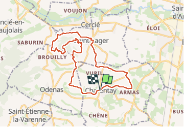

Length
17.9 km

Max alt
482 m

Uphill gradient
508 m
Km-Effort
25 km

Min alt
187 m

Downhill gradient
507 m
Boucle
Yes
Creation date :
2025-03-10 08:02:21.0
Updated on :
2025-03-28 10:53:19.93
5h35
Difficulty : Very difficult

FREE GPS app for hiking
 SityTrail
IGN / Geographical institutes
SityTrail Plus
The world is yours!
About
Trail Walking of 17.9 km to be discovered at Auvergne-Rhône-Alpes, Rhône, Charentay. This trail is proposed by Thomasdanielle.
Description
D/A : grand parking centre village
Positioning
Country:
France
Region :
Auvergne-Rhône-Alpes
Department/Province :
Rhône
Municipality :
Charentay
Location:
Unknown
Start:(Dec)
Start:(UTM)
629781 ; 5105216 (31T) N.
Comments