


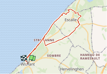
Cap Blanc Nez

CSR-JPM
User

Length
17.2 km

Max alt
147 m

Uphill gradient
303 m
Km-Effort
21 km

Min alt
-1 m

Downhill gradient
302 m
Boucle
Yes
Creation date :
2025-03-10 09:12:37.482
Updated on :
2025-03-10 14:59:33.958
5h46
Difficulty : Very difficult

FREE GPS app for hiking
 SityTrail
IGN / Geographical institutes
SityTrail Plus
The world is yours!
About
Trail Walking of 17.2 km to be discovered at Hauts-de-France, Pas-de-Calais, Wissant. This trail is proposed by CSR-JPM.
Positioning
Country:
France
Region :
Hauts-de-France
Department/Province :
Pas-de-Calais
Municipality :
Wissant
Location:
Unknown
Start:(Dec)
Start:(UTM)
406009 ; 5637877 (31U) N.
Comments