


pont de la mariee point sublime

Christine Cadas
User
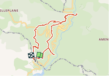

Length
12.3 km

Max alt
1177 m

Uphill gradient
748 m
Km-Effort
22 km

Min alt
746 m

Downhill gradient
749 m
Boucle
Yes
Creation date :
2025-03-06 07:45:16.419
Updated on :
2025-03-10 15:30:58.558
6h28
Difficulty : Medium

FREE GPS app for hiking
 SityTrail
IGN / Geographical institutes
SityTrail Plus
The world is yours!
About
Trail Walking of 12.3 km to be discovered at Provence-Alpes-Côte d'Azur, Maritime Alps, Daluis. This trail is proposed by Christine Cadas.
Positioning
Country:
France
Region :
Provence-Alpes-Côte d'Azur
Department/Province :
Maritime Alps
Municipality :
Daluis
Location:
Unknown
Start:(Dec)
Start:(UTM)
326391 ; 4878818 (32T) N.
Comments