


Col du Perier - La Verne

Vox463
User
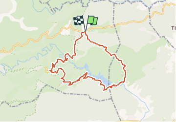

Length
18.4 km

Max alt
429 m

Uphill gradient
756 m
Km-Effort
28 km

Min alt
51 m

Downhill gradient
752 m
Boucle
Yes
Creation date :
2025-03-10 16:19:42.744
Updated on :
2025-03-10 17:35:05.26
6h28
Difficulty : Very difficult

FREE GPS app for hiking
 SityTrail
IGN / Geographical institutes
SityTrail Plus
The world is yours!
About
Trail Walking of 18.4 km to be discovered at Provence-Alpes-Côte d'Azur, Var, Collobrières. This trail is proposed by Vox463.
Positioning
Country:
France
Region :
Provence-Alpes-Côte d'Azur
Department/Province :
Var
Municipality :
Collobrières
Location:
Unknown
Start:(Dec)
Start:(UTM)
291064 ; 4792362 (32T) N.
Comments