


Rueil la Gadelière 7.8-10794906

togolo28
User
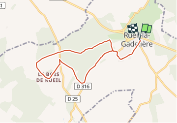

Length
7.8 km

Max alt
181 m

Uphill gradient
67 m
Km-Effort
8.7 km

Min alt
157 m

Downhill gradient
67 m
Boucle
Yes
Creation date :
2025-03-10 17:40:15.68
Updated on :
2025-03-10 17:40:47.257
--
Difficulty : Easy

FREE GPS app for hiking
 SityTrail
IGN / Geographical institutes
SityTrail Plus
The world is yours!
About
Trail Walking of 7.8 km to be discovered at Centre-Loire Valley, Eure-et-Loir, Rueil-la-Gadelière. This trail is proposed by togolo28.
Positioning
Country:
France
Region :
Centre-Loire Valley
Department/Province :
Eure-et-Loir
Municipality :
Rueil-la-Gadelière
Location:
Unknown
Start:(Dec)
Start:(UTM)
351129 ; 5397688 (31U) N.
Comments