


candé gs 16km

cristinette
User
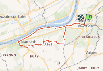

Length
16.4 km

Max alt
120 m

Uphill gradient
116 m
Km-Effort
17.9 km

Min alt
58 m

Downhill gradient
116 m
Boucle
Yes
Creation date :
2025-03-11 07:28:14.368
Updated on :
2025-03-11 11:15:15.795
3h23
Difficulty : Easy

FREE GPS app for hiking
 SityTrail
IGN / Geographical institutes
SityTrail Plus
The world is yours!
About
Trail Walking of 16.4 km to be discovered at Centre-Loire Valley, Loir-et-Cher, Candé-sur-Beuvron. This trail is proposed by cristinette.
Positioning
Country:
France
Region :
Centre-Loire Valley
Department/Province :
Loir-et-Cher
Municipality :
Candé-sur-Beuvron
Location:
Unknown
Start:(Dec)
Start:(UTM)
368965 ; 5261579 (31T) N.
Comments