


Bira fouché eucher beaumanoir Modette champs vert

sameja
User

Length
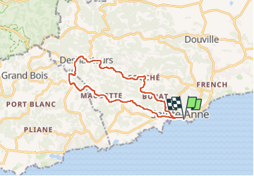
17.6 km

Max alt
130 m

Uphill gradient
281 m
Km-Effort
21 km

Min alt
0 m

Downhill gradient
281 m
Boucle
Yes
Creation date :
2025-03-11 09:07:01.0
Updated on :
2025-03-11 11:42:48.978
2h14
Difficulty : Difficult

FREE GPS app for hiking
 SityTrail
IGN / Geographical institutes
SityTrail Plus
The world is yours!
About
Trail Trail of 17.6 km to be discovered at Guadeloupe, Unknown, Sainte-Anne. This trail is proposed by sameja.
Description
Champs vert
Photos


Positioning
Country:
France
Region :
Guadeloupe
Department/Province :
Unknown
Municipality :
Sainte-Anne
Location:
Unknown
Start:(Dec)
Start:(UTM)
672766 ; 1794295 (20Q) N.
Comments