


Le Sancy

ARVIEU
User
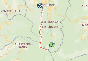

Length
5.9 km

Max alt
1813 m

Uphill gradient
62 m
Km-Effort
8.6 km

Min alt
1236 m

Downhill gradient
628 m
Boucle
No
Creation date :
2025-03-11 13:04:00.808
Updated on :
2025-03-11 13:05:35.556
2h00
Difficulty : Medium

FREE GPS app for hiking
 SityTrail
IGN / Geographical institutes
SityTrail Plus
The world is yours!
About
Trail Walking of 5.9 km to be discovered at Auvergne-Rhône-Alpes, Puy-de-Dôme, Chastreix. This trail is proposed by ARVIEU.
Description
Montée par le téléphérique jusqu'au Sancy, descente sur le Capucin, retour par le funiculaire du Capucin
Positioning
Country:
France
Region :
Auvergne-Rhône-Alpes
Department/Province :
Puy-de-Dôme
Municipality :
Chastreix
Location:
Unknown
Start:(Dec)
Start:(UTM)
485295 ; 5041848 (31T) N.
Comments