


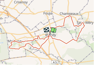
Blandy V3

JacquesMARQUET
User

Length
22 km

Max alt
103 m

Uphill gradient
222 m
Km-Effort
25 km

Min alt
60 m

Downhill gradient
222 m
Boucle
Yes
Creation date :
2025-03-11 15:01:20.704
Updated on :
2025-03-11 15:07:12.77
5h37
Difficulty : Very difficult

FREE GPS app for hiking
 SityTrail
IGN / Geographical institutes
SityTrail Plus
The world is yours!
About
Trail Walking of 22 km to be discovered at Ile-de-France, Seine-et-Marne, Blandy. This trail is proposed by JacquesMARQUET.
Positioning
Country:
France
Region :
Ile-de-France
Department/Province :
Seine-et-Marne
Municipality :
Blandy
Location:
Unknown
Start:(Dec)
Start:(UTM)
483882 ; 5379287 (31U) N.
Comments