


pen be

apa
User
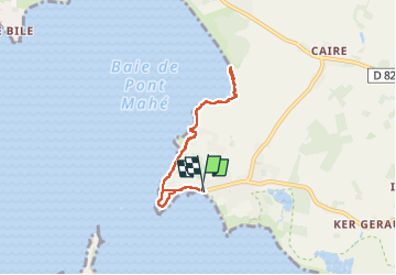

Length
5.7 km

Max alt
17 m

Uphill gradient
50 m
Km-Effort
6.3 km

Min alt
0 m

Downhill gradient
48 m
Boucle
Yes
Creation date :
2025-03-11 14:22:03.658
Updated on :
2025-03-11 16:16:03.24
1h53
Difficulty : Easy

FREE GPS app for hiking
 SityTrail
IGN / Geographical institutes
SityTrail Plus
The world is yours!
About
Trail Walking of 5.7 km to be discovered at Pays de la Loire, Loire-Atlantique, Assérac. This trail is proposed by apa.
Description
panoramique

Positioning
Country:
France
Region :
Pays de la Loire
Department/Province :
Loire-Atlantique
Municipality :
Assérac
Location:
Unknown
Start:(Dec)
Start:(UTM)
541391 ; 5252616 (30T) N.
Comments