


les 2 Ponts/ Ispagnac

tyntyn
User
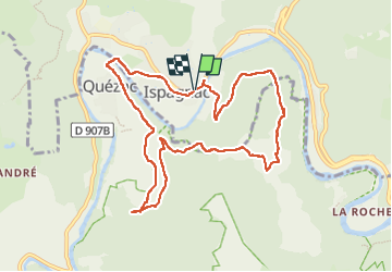

Length
10.5 km

Max alt
751 m

Uphill gradient
391 m
Km-Effort
15.7 km

Min alt
503 m

Downhill gradient
390 m
Boucle
Yes
Creation date :
2025-03-12 12:23:30.88
Updated on :
2025-03-12 16:04:45.477
3h40
Difficulty : Easy

FREE GPS app for hiking
 SityTrail
IGN / Geographical institutes
SityTrail Plus
The world is yours!
About
Trail Walking of 10.5 km to be discovered at Occitania, Lozère, Ispagnac. This trail is proposed by tyntyn.
Positioning
Country:
France
Region :
Occitania
Department/Province :
Lozère
Municipality :
Ispagnac
Location:
Unknown
Start:(Dec)
Start:(UTM)
542872 ; 4913181 (31T) N.
Comments