


Ferréol berne reco chemin

clintest
User
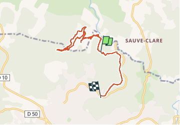

Length
8.4 km

Max alt
306 m

Uphill gradient
243 m
Km-Effort
11.7 km

Min alt
214 m

Downhill gradient
267 m
Boucle
No
Creation date :
2025-03-13 10:33:53.829
Updated on :
2025-03-13 13:24:43.738
2h24
Difficulty : Medium

FREE GPS app for hiking
 SityTrail
IGN / Geographical institutes
SityTrail Plus
The world is yours!
About
Trail Walking of 8.4 km to be discovered at Provence-Alpes-Côte d'Azur, Var, Lorgues. This trail is proposed by clintest.
Photos


Positioning
Country:
France
Region :
Provence-Alpes-Côte d'Azur
Department/Province :
Var
Municipality :
Lorgues
Location:
Unknown
Start:(Dec)
Start:(UTM)
287687 ; 4821047 (32T) N.
Comments