


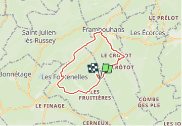
Rallye à la ferme Le puits du Glaçon, circuit 12 km

billodmorelpatrick
User

Length
11.6 km

Max alt
966 m

Uphill gradient
221 m
Km-Effort
14.6 km

Min alt
851 m

Downhill gradient
221 m
Boucle
Yes
Creation date :
2025-03-13 14:10:32.715
Updated on :
2025-03-13 14:14:43.049
3h18
Difficulty : Difficult

FREE GPS app for hiking
 SityTrail
IGN / Geographical institutes
SityTrail Plus
The world is yours!
About
Trail Walking of 11.6 km to be discovered at Bourgogne-Franche-Comté, Doubs, Les Fontenelles. This trail is proposed by billodmorelpatrick.
Description
Le puits du Glaçon, Frambouhans, crêtes piont de vue sur les Alpes Bernoise, chapelle St Anne, lavogne.

Positioning
Country:
France
Region :
Bourgogne-Franche-Comté
Department/Province :
Doubs
Municipality :
Les Fontenelles
Location:
Unknown
Start:(Dec)
Start:(UTM)
330676 ; 5229460 (32T) N.
Comments