


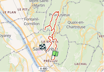
Belvédère du Scialet en circuit et avec les transports en commun (tram A et E)

Emelle
User

Length
14.9 km

Max alt
801 m

Uphill gradient
787 m
Km-Effort
25 km

Min alt
205 m

Downhill gradient
781 m
Boucle
No
Creation date :
2025-03-13 08:31:32.986
Updated on :
2025-03-13 15:49:49.051
5h45
Difficulty : Medium

FREE GPS app for hiking
 SityTrail
IGN / Geographical institutes
SityTrail Plus
The world is yours!
About
Trail Walking of 14.9 km to be discovered at Auvergne-Rhône-Alpes, Isère, Saint-Égrève. This trail is proposed by Emelle.
Description
Pas de difficultés techniques mais quelques montées soutenues.
Positioning
Country:
France
Region :
Auvergne-Rhône-Alpes
Department/Province :
Isère
Municipality :
Saint-Égrève
Location:
Unknown
Start:(Dec)
Start:(UTM)
711113 ; 5011256 (31T) N.
Comments