


PNR Haut-Jura 6/7 Chézery-Forens à L'Embossieux - 11,7 km - 5h00

Bastet
User
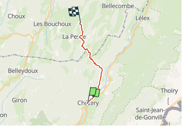

Length
11.6 km

Max alt
1318 m

Uphill gradient
835 m
Km-Effort
21 km

Min alt
583 m

Downhill gradient
256 m
Boucle
No
Creation date :
2018-05-14 00:00:00.0
Updated on :
2018-05-14 00:00:00.0
5h00
Difficulty : Medium

FREE GPS app for hiking
 SityTrail
IGN / Geographical institutes
SityTrail Plus
The world is yours!
About
Trail Walking of 11.6 km to be discovered at Auvergne-Rhône-Alpes, Ain, Chézery-Forens. This trail is proposed by Bastet.
Positioning
Country:
France
Region :
Auvergne-Rhône-Alpes
Department/Province :
Ain
Municipality :
Chézery-Forens
Location:
Unknown
Start:(Dec)
Start:(UTM)
721025 ; 5122690 (31T) N.
Comments