


La Charmouthienne_boucle_Iré-le-Sec(FR)_2025-03-09

bernardcollignon
User
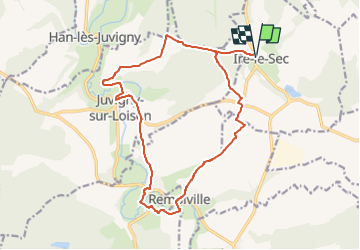

Length
16.7 km

Max alt
311 m

Uphill gradient
301 m
Km-Effort
21 km

Min alt
181 m

Downhill gradient
301 m
Boucle
Yes
Creation date :
2025-03-14 13:59:30.081
Updated on :
2025-03-14 14:26:34.352
4h42
Difficulty : Very difficult

FREE GPS app for hiking
 SityTrail
IGN / Geographical institutes
SityTrail Plus
The world is yours!
About
Trail Walking of 16.7 km to be discovered at Grand Est, Meuse, Iré-le-Sec. This trail is proposed by bernardcollignon.
Positioning
Country:
France
Region :
Grand Est
Department/Province :
Meuse
Municipality :
Iré-le-Sec
Location:
Unknown
Start:(Dec)
Start:(UTM)
672948 ; 5483076 (31U) N.
Comments