


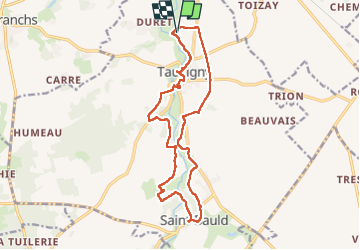
Tauxigny Observatoire - Saint-Bauld - 15.8km 185m 3h30 (40mn) - 2025 03 15

Orcal37
User GUIDE

Length
15.8 km

Max alt
99 m

Uphill gradient
185 m
Km-Effort
18.3 km

Min alt
72 m

Downhill gradient
186 m
Boucle
Yes
Creation date :
2025-03-15 10:07:44.635
Updated on :
2025-03-17 12:11:24.05
3h30
Difficulty : Easy

FREE GPS app for hiking
 SityTrail
IGN / Geographical institutes
SityTrail Plus
The world is yours!
About
Trail Walking of 15.8 km to be discovered at Centre-Loire Valley, Indre-et-Loire, Tauxigny-Saint-Bauld. This trail is proposed by Orcal37.
Description
Tauxigny Observatoire - Observatoire Astronomique - Tauxigny - Saint-Bauld - 15.8km 185m 3h30 (40mn) - 2025 03 15
Photos
 - 2025 03 15 - Photo 1")
 - 2025 03 15 - Photo 2")
 - 2025 03 15 - Photo 3")
 - 2025 03 15 - Photo 4")
 - 2025 03 15 - Photo 5")
 - 2025 03 15 - Photo 6")
 - 2025 03 15 - Photo 7")
 - 2025 03 15 - Photo 8")
 - 2025 03 15 - Photo 9")
 - 2025 03 15 - Photo 10")
Positioning
Country:
France
Region :
Centre-Loire Valley
Department/Province :
Indre-et-Loire
Municipality :
Tauxigny-Saint-Bauld
Location:
Tauxigny
Start:(Dec)
Start:(UTM)
335907 ; 5232333 (31T) N.
Comments