


Pic d'Alian

chasle
User
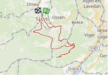

Length
10.4 km

Max alt
1080 m

Uphill gradient
642 m
Km-Effort
19 km

Min alt
557 m

Downhill gradient
644 m
Boucle
Yes
Creation date :
2025-03-16 08:13:55.639
Updated on :
2025-03-16 16:06:55.316
4h18
Difficulty : Difficult

FREE GPS app for hiking
 SityTrail
IGN / Geographical institutes
SityTrail Plus
The world is yours!
About
Trail Walking of 10.4 km to be discovered at Occitania, Hautespyrenees, Ségus. This trail is proposed by chasle.
Positioning
Country:
France
Region :
Occitania
Department/Province :
Hautespyrenees
Municipality :
Ségus
Location:
Unknown
Start:(Dec)
Start:(UTM)
738086 ; 4772762 (30T) N.
Comments