


2025-03-16 Achenheim-Kolbsheim

Mich&Agnès
User
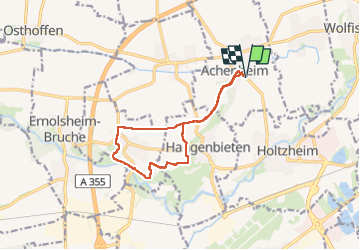

Length
11.2 km

Max alt
208 m

Uphill gradient
126 m
Km-Effort
12.9 km

Min alt
147 m

Downhill gradient
126 m
Boucle
Yes
Creation date :
2025-03-16 13:34:30.359
Updated on :
2025-03-16 15:37:57.655
2h02
Difficulty : Very easy

FREE GPS app for hiking
 SityTrail
IGN / Geographical institutes
SityTrail Plus
The world is yours!
About
Trail Walking of 11.2 km to be discovered at Grand Est, Bas-Rhin, Achenheim. This trail is proposed by Mich&Agnès.
Description
balade sur les hauteurs du kochersberg. Préférer la fin de l'hiver par temps sec.
Chemins aux gréés des labours...
Positioning
Country:
France
Region :
Grand Est
Department/Province :
Bas-Rhin
Municipality :
Achenheim
Location:
Unknown
Start:(Dec)
Start:(UTM)
398852 ; 5381248 (32U) N.
Comments