


ppp

tosan
User
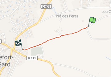

Length
787 m

Max alt
89 m

Uphill gradient
21 m
Km-Effort
997 m

Min alt
66 m

Downhill gradient
0 m
Boucle
No
Creation date :
2025-03-16 17:18:58.236
Updated on :
2025-03-16 17:24:07.028
4m
Difficulty : Very easy

FREE GPS app for hiking
 SityTrail
IGN / Geographical institutes
SityTrail Plus
The world is yours!
About
Trail Running of 787 m to be discovered at Occitania, Gard, Rochefort-du-Gard. This trail is proposed by tosan.
Positioning
Country:
France
Region :
Occitania
Department/Province :
Gard
Municipality :
Rochefort-du-Gard
Location:
Unknown
Start:(Dec)
Start:(UTM)
636568 ; 4870752 (31T) N.
Comments