Trail Other activity Damelevières - Grand Est - Ligne 16 - Blainville-Damelevières Aillevillers (Belfort) - Photo

Grand Est - Ligne 16 - Blainville-Damelevières Aillevillers (Belfort)

 mich54
mich54

User

© OpenStreetMap contributors
Length
Length
93 km
Max alt
Max alt
451 m
Uphill gradient
Uphill gradient
988 m
Km-Effort
Km-Effort  
106 km
Min alt
Min alt
212 m
Downhill gradient
Downhill gradient
915 m
Boucle
Boucle
No
Creation date :
2017-03-03 00:00:00.0
Updated on :
2017-03-03 00:00:00.0

(0 Reviews)

Other activity
Other activity
5m
Difficulty : Unknown

Scan this QR Code to open this trail in the SityTrail application

FREE GPS app for hiking

Logo SityTrail SityTrail

IGN / Geographical institutes

Download SityTrail from the App Store Download SityTrail from Google Play

Logo SityTrail SityTrail World

The world is yours!

Download SityTrail from the App Store Download SityTrail from Google Play Download SityTrail on Huawei AppGallery

About

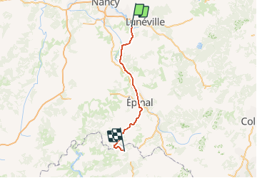
Trail Other activity of 93 km to be discovered at Grand Est, Meurthe-et-Moselle, Damelevières. This trail is proposed by mich54.

Description

En cours de traitement
(Concept protégé INPI)

Elevation profile

Photos

Points of interest

Point of interest Damelevières - Blainville-Damelevières - Photo
mich54
Point of interest Einvaux - Einvaux - Photo
mich54
EINVAUX 
Point of interest Virecourt - Bayon - Photo
mich54
VIRECOURT 
Point of interest Charmes - Charmes - Photo
mich54
CHARMES 
Point of interest Portieux - Vincey - Photo
mich54
PORTIEUX 
Point of interest Nomexy - Chatel-Nomexy - Photo
mich54
Point of interest Igney - Igney - Photo
mich54
IGNEY 
Point of interest Capavenir-Vosges - Thaon - Photo
mich54
CAPAVENIR-VOSGES 
Point of interest Épinal - Epinal - Photo
mich54
ÉPINAL 

Positioning

Country:
France
Region :
Grand Est
Department/Province :
Meurthe-et-Moselle
Municipality :
Damelevières
Location:
Unknown
Start:(UTM)
307135 ; 5382435 (32U) N.

Trails nearby

Trail Walking Vitrimont - Circuit des Quatre Vents - Photo
Walking
Le_Grand

Walking

Easy
(1)
Vitrimont, Grand Est, Meurthe-et-Moselle, France
9.4 km | 11.7 km-effort
2h 31min
Yes
Trail Mountain bike Vitrimont - sortie vtt du 11112018 vitrimont ok - Photo
Mountain bike
GUIDE
fabwin

Mountain bike

Medium
Vitrimont, Grand Est, Meurthe-et-Moselle, France
23 km | 28 km-effort
1h 50min
Yes
Trail Mountain bike Vitrimont - sortie vtt du 24062018 vitrimont leomont  - Photo
Mountain bike
GUIDE
fabwin

Mountain bike

Medium
Vitrimont, Grand Est, Meurthe-et-Moselle, France
29 km | 35 km-effort
2h 20min
Yes
Trail Mountain bike Vitrimont - sortie vtt du 27042018 vitrimont  - Photo
Mountain bike
GUIDE
fabwin

Mountain bike

Medium
Vitrimont, Grand Est, Meurthe-et-Moselle, France
25 km | 30 km-effort
1h 58min
Yes
Trail Electric bike Rosières-aux-Salines - sortie vtt 21022023 rosière aux salines - Photo
Electric bike
GUIDE
fabwin

Electric bike

Difficult
Rosières-aux-Salines, Grand Est, Meurthe-et-Moselle, France
46 km | 53 km-effort
2h 6min
Yes
Trail Walking Rosières-aux-Salines - rosières aux salines - Photo
Walking
JJG54

Walking

Medium
Rosières-aux-Salines, Grand Est, Meurthe-et-Moselle, France
14.3 km | 16.6 km-effort
3h 9min
Yes
Trail Coupling Rosières-aux-Salines - Rosieres, route des vergers, tour de Nancy - Photo
Coupling
agnesbernardi

Coupling

Medium
Rosières-aux-Salines, Grand Est, Meurthe-et-Moselle, France
9.8 km | 11.7 km-effort
1h 43min
No
Trail Mountain bike Vitrimont - Circuit des 4 vents - Vitrimont - Photo
Mountain bike
tracegps

Mountain bike

Easy
Vitrimont, Grand Est, Meurthe-et-Moselle, France
10.5 km | 12.8 km-effort
45min
Yes
Trail Walking Blainville-sur-l'Eau - mag_09062019 - Photo
Walking
grandville

Walking

Very easy
Blainville-sur-l'Eau, Grand Est, Meurthe-et-Moselle, France
26 km | 30 km-effort
4h 34min
Yes


Close
My subscriptions