


Olne fin

castorgris
User
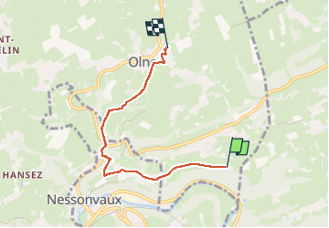

Length
4.2 km

Max alt
261 m

Uphill gradient
121 m
Km-Effort
5.9 km

Min alt
123 m

Downhill gradient
136 m
Boucle
No
Creation date :
2025-03-17 09:54:20.0
Updated on :
2025-03-17 11:15:24.396

FREE GPS app for hiking
 SityTrail
IGN / Geographical institutes
SityTrail Plus
The world is yours!
About
Trail of 4.2 km to be discovered at Wallonia, Liège, Olne. This trail is proposed by castorgris.
Positioning
Country:
Belgium
Region :
Wallonia
Department/Province :
Liège
Municipality :
Olne
Location:
Unknown
Start:(Dec)
Start:(UTM)
695683 ; 5606485 (31U) N.
Comments