


Lablachere Remejadou

pb07
User
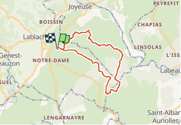

Length
14.3 km

Max alt
294 m

Uphill gradient
189 m
Km-Effort
16.8 km

Min alt
195 m

Downhill gradient
189 m
Boucle
Yes
Creation date :
2025-03-17 09:06:29.937
Updated on :
2025-03-17 15:27:50.423
4h45
Difficulty : Medium

FREE GPS app for hiking
 SityTrail
IGN / Geographical institutes
SityTrail Plus
The world is yours!
About
Trail Walking of 14.3 km to be discovered at Auvergne-Rhône-Alpes, Ardèche, Lablachère. This trail is proposed by pb07.
Positioning
Country:
France
Region :
Auvergne-Rhône-Alpes
Department/Province :
Ardèche
Municipality :
Lablachère
Location:
Unknown
Start:(Dec)
Start:(UTM)
597534 ; 4923574 (31T) N.
Comments