


Compostelle Vaithiermont

chantalwaltzer
User
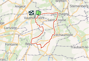

Length
14 km

Max alt
410 m

Uphill gradient
194 m
Km-Effort
16.6 km

Min alt
340 m

Downhill gradient
193 m
Boucle
Yes
Creation date :
2025-03-16 08:10:23.0
Updated on :
2025-03-18 07:38:47.193
6h57
Difficulty : Difficult

FREE GPS app for hiking
 SityTrail
IGN / Geographical institutes
SityTrail Plus
The world is yours!
About
Trail Walking of 14 km to be discovered at Bourgogne-Franche-Comté, Territoire-de-Belfort, Vauthiermont. This trail is proposed by chantalwaltzer.
Description
marche
Positioning
Country:
France
Region :
Bourgogne-Franche-Comté
Department/Province :
Territoire-de-Belfort
Municipality :
Vauthiermont
Location:
Unknown
Start:(Dec)
Start:(UTM)
352324 ; 5283131 (32T) N.
Comments