


promenade forestière St pancré

veroberton
User
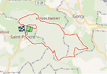

Length
9.6 km

Max alt
401 m

Uphill gradient
295 m
Km-Effort
13.5 km

Min alt
278 m

Downhill gradient
294 m
Boucle
Yes
Creation date :
2025-03-17 13:08:46.07
Updated on :
2025-03-18 12:16:32.779
2h30
Difficulty : Medium

FREE GPS app for hiking
 SityTrail
IGN / Geographical institutes
SityTrail Plus
The world is yours!
About
Trail Walking of 9.6 km to be discovered at Grand Est, Meurthe-et-Moselle, Saint-Pancré. This trail is proposed by veroberton.
Positioning
Country:
France
Region :
Grand Est
Department/Province :
Meurthe-et-Moselle
Municipality :
Saint-Pancré
Location:
Unknown
Start:(Dec)
Start:(UTM)
691848 ; 5489682 (31U) N.
Comments