


20250318 coline rocade

Jeanclaudebic
User
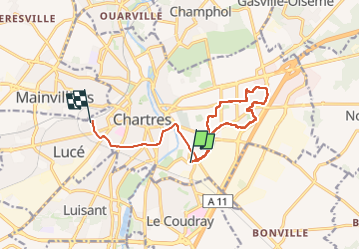

Length
12.4 km

Max alt
161 m

Uphill gradient
88 m
Km-Effort
13.6 km

Min alt
127 m

Downhill gradient
85 m
Boucle
No
Creation date :
2025-03-18 12:32:06.331
Updated on :
2025-03-18 14:44:16.712
2h11
Difficulty : Difficult

FREE GPS app for hiking
 SityTrail
IGN / Geographical institutes
SityTrail Plus
The world is yours!
About
Trail Walking of 12.4 km to be discovered at Centre-Loire Valley, Eure-et-Loir, Chartres. This trail is proposed by Jeanclaudebic.
Positioning
Country:
France
Region :
Centre-Loire Valley
Department/Province :
Eure-et-Loir
Municipality :
Chartres
Location:
Unknown
Start:(Dec)
Start:(UTM)
389403 ; 5365607 (31U) N.
Comments