


sortie 18x03x2025

Didier-114
User

Length
8.4 km

Max alt
167 m

Uphill gradient
159 m
Km-Effort
10.5 km

Min alt
82 m

Downhill gradient
158 m
Boucle
Yes
Creation date :
2025-03-18 12:39:33.126
Updated on :
2025-03-18 15:22:52.7
2h41
Difficulty : Medium

FREE GPS app for hiking
 SityTrail
IGN / Geographical institutes
SityTrail Plus
The world is yours!
About
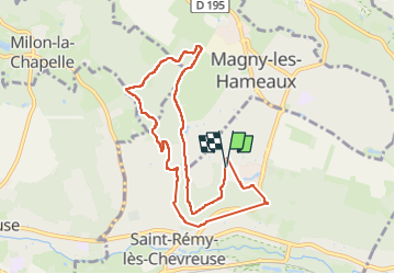
Trail Walking of 8.4 km to be discovered at Ile-de-France, Yvelines, Saint-Rémy-lès-Chevreuse. This trail is proposed by Didier-114.
Positioning
Country:
France
Region :
Ile-de-France
Department/Province :
Yvelines
Municipality :
Saint-Rémy-lès-Chevreuse
Location:
Unknown
Start:(Dec)
Start:(UTM)
432273 ; 5396061 (31U) N.
Comments