


2025-03-18

rando30129
User
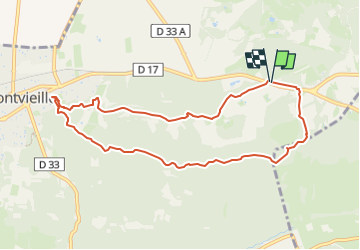

Length
9.4 km

Max alt
108 m

Uphill gradient
140 m
Km-Effort
11.3 km

Min alt
30 m

Downhill gradient
143 m
Boucle
Yes
Creation date :
2025-03-18 12:46:18.246
Updated on :
2025-05-26 13:47:19.303
2h34
Difficulty : Medium

FREE GPS app for hiking
 SityTrail
IGN / Geographical institutes
SityTrail Plus
The world is yours!
About
Trail Walking of 9.4 km to be discovered at Provence-Alpes-Côte d'Azur, Bouches-du-Rhône, Fontvieille. This trail is proposed by rando30129.
Photos


Positioning
Country:
France
Region :
Provence-Alpes-Côte d'Azur
Department/Province :
Bouches-du-Rhône
Municipality :
Fontvieille
Location:
Unknown
Start:(Dec)
Start:(UTM)
640982 ; 4843195 (31T) N.
Comments