


Chateauneuf sur isere

meillon
User
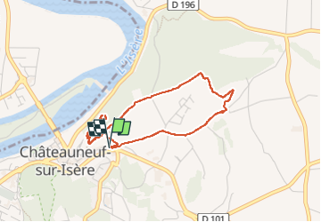

Length
4.1 km

Max alt
232 m

Uphill gradient
109 m
Km-Effort
5.6 km

Min alt
159 m

Downhill gradient
108 m
Boucle
Yes
Creation date :
2025-03-19 10:48:39.426
Updated on :
2025-03-19 13:19:43.436
2h30
Difficulty : Easy

FREE GPS app for hiking
 SityTrail
IGN / Geographical institutes
SityTrail Plus
The world is yours!
About
Trail Walking of 4.1 km to be discovered at Auvergne-Rhône-Alpes, Drôme, Châteauneuf-sur-Isère. This trail is proposed by meillon.
Description
panorama sur les barrages et les carrieres
Positioning
Country:
France
Region :
Auvergne-Rhône-Alpes
Department/Province :
Drôme
Municipality :
Châteauneuf-sur-Isère
Location:
Unknown
Start:(Dec)
Start:(UTM)
653130 ; 4986543 (31T) N.
Comments