


trace

cramcl50
User
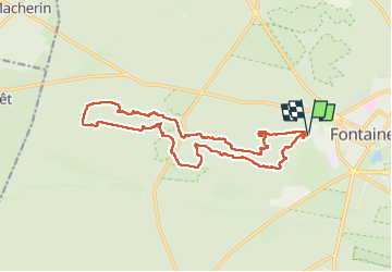

Length
17.3 km

Max alt
141 m

Uphill gradient
261 m
Km-Effort
21 km

Min alt
79 m

Downhill gradient
263 m
Boucle
Yes
Creation date :
2025-03-18 08:40:13.428
Updated on :
2025-03-19 18:43:08.857
6h50
Difficulty : Very difficult

FREE GPS app for hiking
 SityTrail
IGN / Geographical institutes
SityTrail Plus
The world is yours!
About
Trail Walking of 17.3 km to be discovered at Ile-de-France, Seine-et-Marne, Fontainebleau. This trail is proposed by cramcl50.

Positioning
Country:
France
Region :
Ile-de-France
Department/Province :
Seine-et-Marne
Municipality :
Fontainebleau
Location:
Unknown
Start:(Dec)
Start:(UTM)
476159 ; 5361328 (31U) N.
Comments