


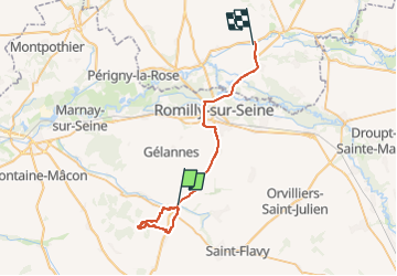
St Martin , Rigny, les Boulins

NANE51
User

Length
33 km

Max alt
161 m

Uphill gradient
227 m
Km-Effort
37 km

Min alt
67 m

Downhill gradient
257 m
Boucle
No
Creation date :
2025-03-20 07:52:34.0
Updated on :
2025-03-20 12:20:22.493
3h11
Difficulty : Easy

FREE GPS app for hiking
 SityTrail
IGN / Geographical institutes
SityTrail Plus
The world is yours!
About
Trail Walking of 33 km to be discovered at Grand Est, Aube, Saint-Martin-de-Bossenay. This trail is proposed by NANE51.
Positioning
Country:
France
Region :
Grand Est
Department/Province :
Aube
Municipality :
Saint-Martin-de-Bossenay
Location:
Unknown
Start:(Dec)
Start:(UTM)
550443 ; 5365522 (31U) N.
Comments