


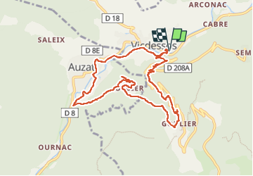
Vicdessos/Or ier/Goulier

loic09
User

Length
10.6 km

Max alt
1092 m

Uphill gradient
470 m
Km-Effort
16.9 km

Min alt
706 m

Downhill gradient
470 m
Boucle
Yes
Creation date :
2025-03-20 08:53:17.446
Updated on :
2025-03-20 14:06:39.591
3h11
Difficulty : Easy

FREE GPS app for hiking
 SityTrail
IGN / Geographical institutes
SityTrail Plus
The world is yours!
About
Trail Walking of 10.6 km to be discovered at Occitania, Ariège, Val-de-Sos. This trail is proposed by loic09.
Description
Randonnée par les ruines du château de Montréal de Sos
Positioning
Country:
France
Region :
Occitania
Department/Province :
Ariège
Municipality :
Val-de-Sos
Location:
Unknown
Start:(Dec)
Start:(UTM)
377355 ; 4736170 (31T) N.
Comments