


Hourquette de Mont Agut

chasle
User
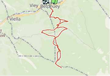

Length
10.9 km

Max alt
2047 m

Uphill gradient
1041 m
Km-Effort
25 km

Min alt
1009 m

Downhill gradient
1038 m
Boucle
Yes
Creation date :
2025-03-20 08:10:10.542
Updated on :
2025-03-20 16:57:16.339
4h09
Difficulty : Difficult

FREE GPS app for hiking
 SityTrail
IGN / Geographical institutes
SityTrail Plus
The world is yours!
About
Trail Walking of 10.9 km to be discovered at Occitania, Hautespyrenees, Betpouey. This trail is proposed by chasle.
Positioning
Country:
France
Region :
Occitania
Department/Province :
Hautespyrenees
Municipality :
Betpouey
Location:
Unknown
Start:(Dec)
Start:(UTM)
257745 ; 4751895 (31T) N.
Comments