Trail Walking Wissant - WISSANT Club alpin LILLE - Photo

WISSANT Club alpin LILLE

© OpenStreetMap contributors
Length
Length
26 km
Max alt
Max alt
156 m
Uphill gradient
Uphill gradient
405 m
Km-Effort
Km-Effort  
32 km
Min alt
Min alt
0 m
Downhill gradient
Downhill gradient
405 m
Boucle
Boucle
Yes
Creation date :
2017-06-12 00:00:00.0
Updated on :
2017-06-12 00:00:00.0

(1 Reviews)

Walking
Walking
6h47
Difficulty : Medium

Scan this QR Code to open this trail in the SityTrail application

FREE GPS app for hiking

Logo SityTrail SityTrail

IGN / Geographical institutes

Download SityTrail from the App Store Download SityTrail from Google Play

Logo SityTrail SityTrail World

The world is yours!

Download SityTrail from the App Store Download SityTrail from Google Play Download SityTrail on Huawei AppGallery

About

Trail Walking of 26 km to be discovered at Hauts-de-France, Pas-de-Calais, Wissant. This trail is proposed by reneperrin.

Description

WISSANT gris nez Audinghen M'ont Couple

Elevation profile

Photos

Points of interest

Point of interest Audinghen - Point 6 - Photo
reneperrin
AUDINGHEN 
Point of interest Audinghen - Point 8 - Photo
reneperrin
AUDINGHEN 
Point of interest Audinghen - Point 10 - Photo
reneperrin
AUDINGHEN 
Point of interest Audembert - Point 14 - Photo
reneperrin
AUDEMBERT 

Positioning

Country:
France
Region :
Hauts-de-France
Department/Province :
Pas-de-Calais
Municipality :
Wissant
Location:
Unknown
Start:(UTM)
405902 ; 5637948 (31U) N.

Comments

Please log in to post a review or rate the element


beau parcours proposé par Jean Marc avec le club Alpin de Lulle


Trails nearby

Trail Walking Wissant - Wissant-Mont de Couple- retour par la plage - Photo
Walking
Vagabond gaumardennais

Walking

Difficult
(1)
Wissant, Hauts-de-France, Pas-de-Calais, France
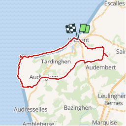
14.3 km | 0 m-effort
2h 53min
Yes
Trail Walking Wissant - Le Fartz - Photo
Walking
terminio

Walking

Very easy
(1)
Wissant, Hauts-de-France, Pas-de-Calais, France
5.5 km | 6.2 km-effort
1h 29min
Yes
Trail Walking Escalles - Les balcons d'Escalles  - Photo
Walking
tracegps

Walking

Medium
(4)
Escalles, Hauts-de-France, Pas-de-Calais, France
7.8 km | 10.5 km-effort
2h 0min
Yes
Trail Walking Sangatte - Le Site des 2 Caps - Les Falaises du Cap Blanc Nez et le Mont d'Hubert - Photo
Walking
tracegps

Walking

Medium
(3)
Sangatte, Hauts-de-France, Pas-de-Calais, France
11.2 km | 14.7 km-effort
3h 0min
Yes
Trail Walking Tardinghen - Le Site des 2 Caps - Le Sentier des Crans - Photo
Walking
tracegps

Walking

Medium
(2)
Tardinghen, Hauts-de-France, Pas-de-Calais, France
12 km | 14.3 km-effort
3h 0min
Yes
Trail Walking Tardinghen - Sentier du Fartz - Waissant - Photo
Walking
tracegps

Walking

Easy
(1)
Tardinghen, Hauts-de-France, Pas-de-Calais, France
5.1 km | 5.8 km-effort
1h 30min
Yes
Trail Walking Tardinghen - Le Site des 2 Caps - Le Sentier des Crans - Photo
Walking
GUIDE
Desrumaux

Walking

Easy
(3)
Tardinghen, Hauts-de-France, Pas-de-Calais, France
12 km | 14.3 km-effort
3h 0min
Yes
Trail Walking Wissant - Le Site des 2 Caps - Le Sentier du Phartz et de la Dune d'Aval - Photo
Walking
GUIDE
Desrumaux

Walking

Easy
(3)
Wissant, Hauts-de-France, Pas-de-Calais, France
7.4 km | 8.3 km-effort
1h 50min
Yes
Trail Walking Sangatte - Le Site des 2 Caps - Les Falaises du Cap Blanc Nez et le Mont d'Hubert - Photo
Walking
GUIDE
Desrumaux

Walking

Easy
(4)
Sangatte, Hauts-de-France, Pas-de-Calais, France
11.2 km | 14.7 km-effort
2h 50min
Yes


Close
My subscriptions