


Test 2 Dourdan le 13 mars-20903803

maxEA65
User
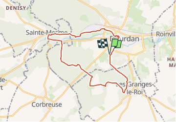

Length
14.8 km

Max alt
167 m

Uphill gradient
266 m
Km-Effort
18.4 km

Min alt
94 m

Downhill gradient
266 m
Boucle
Yes
Creation date :
2025-03-21 07:18:49.659
Updated on :
2025-03-21 07:18:49.659

FREE GPS app for hiking
 SityTrail
IGN / Geographical institutes
SityTrail Plus
The world is yours!
About
Trail of 14.8 km to be discovered at Ile-de-France, Essonne, Dourdan. This trail is proposed by maxEA65.
Positioning
Country:
France
Region :
Ile-de-France
Department/Province :
Essonne
Municipality :
Dourdan
Location:
Unknown
Start:(Dec)
Start:(UTM)
426531 ; 5374719 (31U) N.
Comments