


reconnaissance berne circuit jaune

clintest
User
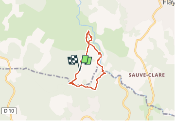

Length
5.7 km

Max alt
288 m

Uphill gradient
129 m
Km-Effort
7.5 km

Min alt
213 m

Downhill gradient
132 m
Boucle
Yes
Creation date :
2025-03-22 08:44:32.037
Updated on :
2025-03-22 10:25:13.091
1h40
Difficulty : Medium

FREE GPS app for hiking
 SityTrail
IGN / Geographical institutes
SityTrail Plus
The world is yours!
About
Trail Walking of 5.7 km to be discovered at Provence-Alpes-Côte d'Azur, Var, Flayosc. This trail is proposed by clintest.
Photos


Positioning
Country:
France
Region :
Provence-Alpes-Côte d'Azur
Department/Province :
Var
Municipality :
Flayosc
Location:
Unknown
Start:(Dec)
Start:(UTM)
286995 ; 4821518 (32T) N.
Comments