


La camp - Riboux

Vox463
User
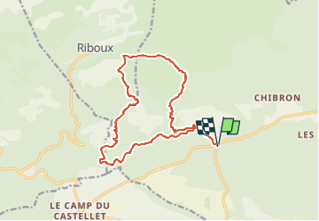

Length
16.4 km

Max alt
592 m

Uphill gradient
338 m
Km-Effort
21 km

Min alt
365 m

Downhill gradient
338 m
Boucle
Yes
Creation date :
2025-03-22 11:28:25.484
Updated on :
2025-03-22 11:29:15.693
4h45
Difficulty : Very difficult

FREE GPS app for hiking
 SityTrail
IGN / Geographical institutes
SityTrail Plus
The world is yours!
About
Trail Walking of 16.4 km to be discovered at Provence-Alpes-Côte d'Azur, Var, Signes. This trail is proposed by Vox463.
Positioning
Country:
France
Region :
Provence-Alpes-Côte d'Azur
Department/Province :
Var
Municipality :
Signes
Location:
Unknown
Start:(Dec)
Start:(UTM)
727560 ; 4795203 (31T) N.
Comments