


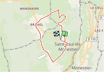
ST Paul les Monetier GR3

michel38
User

Length
7.7 km

Max alt
939 m

Uphill gradient
180 m
Km-Effort
10.1 km

Min alt
783 m

Downhill gradient
179 m
Boucle
Yes
Creation date :
2025-03-22 16:34:00.761
Updated on :
2025-03-22 16:34:50.53
2h18
Difficulty : Medium

FREE GPS app for hiking
 SityTrail
IGN / Geographical institutes
SityTrail Plus
The world is yours!
About
Trail Walking of 7.7 km to be discovered at Auvergne-Rhône-Alpes, Isère, Saint-Paul-lès-Monestier. This trail is proposed by michel38.
Positioning
Country:
France
Region :
Auvergne-Rhône-Alpes
Department/Province :
Isère
Municipality :
Saint-Paul-lès-Monestier
Location:
Unknown
Start:(Dec)
Start:(UTM)
707006 ; 4978650 (31T) N.
Comments